Sunday 25 December 2011

An experiment in flotation soil sample


Yesterday we start the flotation of soil samples of a prehistorical site. We used a hand-made machine developed and built by our friend Simone Pedron of Studio Sestante. Soon we will post some ideas to improve the system.
The picture below shows a phase of the process.

Merry Christmas!

Merry Christmas!

Christmas Tux 2007, licensed by Klowner.com, Creative Commons 3.0 (BY-NC-SA)

Saturday 24 December 2011

Stereoscopy in ArcheOS

Yesterday I received an e-mail asking if it is possible to visualize in ArcheOS stereoscopic image pair.
I worked a little with this kind of technique (e.g. stereophotogrammetry) and also in my thesis I used a related methodology ("Necropoli del Piovego: scavo e documentazione informatica delle tombe 71 e U.F.C. 2", 2003 University of Padua, supervisors Giovanni Leonardi and  Michele Cupitò).
For instance in the image below you can see a comparison between a DEM (Digital Elevation Model) done taking the measurement manually (with the help of a grid) and the same surface done with photogrammetric stereo-reconstruction (for that project I used ERDAS IMAGE software). Of course the model I did manually is too regular to represent reality.


And this is the instrument I used for the left model (thanks to the help of Denis Francisci)


To visualize stereo photo pairs in my thesis I just used anaglyph images (red - cyan), like the one you see here:


In the same way of NASA rover Spirit :)

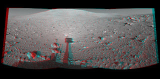
Image credits: NASA, PL-Caltech, Cornell University public domain 

To do anaglyph images I simply used GIMP (which is inside ArcheOS, of course). There are a lot of tutorials about this topic (e.g. this one), so I do not describe here the whole process. Moreover there is also a specific GIMP script (script-fu-make-anaglyph), which we could consider to add in ArcheOS GIMP package (for next release).

Anyway, I guess that the question I received about how to visualize stereoscopic image pairs in ArcheOS was related with something more technical than a simple anaglyph. The best solution (IMHO) is to use efoto, a complete suite for aerial stereophotogrammetry, composed by different modules. Inside ArcheOS all these modules are available from the menu "Photogrammetry".
With this software (developed in Brazil) it is possible to perform a complete aerial photogrammetry project, from internal orientation of the camera, till 3D data extraction from stereo photo-pairs. Normally it is better to complete all the steps of a project (also in this case there are some tutorials), but the module "Stereoplotter" can be simply use to visualize the image pairs, both in stereo and in anaglyph way. The images below are two screenshots I did with the default test data (which you can download with efoto). For soccer fans: In the right corner you can see the Maracanà (Rio de Janeiro)!

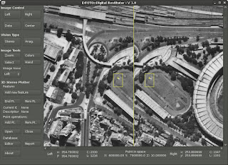
Stereoplotter: stereo vision

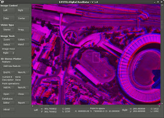
Stereoplotter: anaglyph vision

Friday 23 December 2011

Import data inside VTerrain

Hi all,
yesterday I imported some data (DEM of Non Valley, Trentino - Italy) inside VTerrain. The screenshot below show the result.


The process is pretty simple and it is well describeb in this tutorial.
VTBuilder can convert many kind of data to a BT file, which is needed by the software.

Wednesday 21 December 2011

ArcheOS new release codename

Hi all,
today we started a discussion about next steps in ArcheOS 4 (codename Caesar) development. Unfortunately by now the discussion is just in the Italian mailing list. Anyway one of the milestones we defined is the choice of the codename for the next release. Here you can participate to the vote for the new name. By now we have the following competitors:


King Theodoric
Queen Semiramis
St. Joan of Arc

Queen Nefertari

Queen Nefertiti
King Tamara     


Pharaoh Hatshepsut


As you see, to balance the female quotas in ArcheOS, we have six female candidate and just one men (by now). Let us know who is your favorite! (Hurry up, You can vote until December 31, 2011!)

PS
If you want to propose new names, just write an email in the Italian or English ArcheOS mailing list.

Sunday 11 December 2011

QGIS and Virtual Terrain Project

Yesterday I worked a little bit with Alessandro Bezzi to compile  the source code of Virtual Terrian Project inside ArcheOS 4. This operation was pretty simple, thanks to the instruction written by Roberto (BobMax) in his blog, and everything worked good. Than we tried to combine QGIS and VTP with the script Roberto wrote and, also in this case, we were lucky: to run the software it was necessary just a small correction inside the source code of the python script (a wrong path to the binary executable of Enviro). By now on we can work to build the deb package for ArcheOS, but we still have to clarify some points (especially regarding all the libraries connected with VTP). Anyway i think that, with the help of Roberto, we can package an optimized version of the software, to run with QGIS.
Here is a screenshot of QGIS and VTP with some example data (Hawaii Maui Island).

Saturday 3 December 2011

Lund University lessons (slide)

Today I uploaded on Arc-Team's Open Library the slides of a lessons I did with Alessandro Bezzi in Lund University (SE) in March 2011 (the lessons were possible thanks to the effort of Nicolò Dell'unto). The topic regards computational archaeology and it is maybe a "theory lesson", but it can be also useful to have an overview of what it is possible to do with FLOSS in archaeology (and in particular with ArcheOS). Below you see a couple of slides from this lesson.


Thursday 1 December 2011

v.out.labpoints

In www.uselessarchaeology.it you can find theoretical and practical research topics of archaeological methodology. In the last days I added a section of GRASS scripting.
In this section is now downloadable a new GRASS script for exporting a georeferenced raster image of labeled points: v.out.labpoints. It is useful for image rectification through raster model, e.g. using E-Foto in "Aramus" documentation method (see https://wiki.uibk.ac.at/confluence/display/excavationtutor/creazione_fotomosaici). This script enable users to speed the rectification process joining several steps just in one command.
The usage is described in the web page and in the script file. In the next days I'll posted a simple tutorial with an example.

Script (and its name as well) is under construction. It must be developed in order to change variables through shell commands without opening the script file. Moreover need to build a GRASS GUI for this script. In future, the developed script could be add to ArcheOS.

Any contribution or suggestion are welcome.
BlogItalia - La directory italiana dei blog Creative Commons License
This work is licensed under a Creative Commons Attribution 4.0 International License.